Date – August 22, 2015
Location – Maps 40 Dyer’s Bay and 41 Emmett Lake
Distance – 20.2
Total Trail Distance – 863.6 (30.4 to go)
Hikers – Dean, Marlene, Benjamin, Steve, Simon, Jacob, Madeleine, Kent,
Harold, Janette, Melanie and Chris
Start – 116.8 Dyer’s Bay Road
End – 137.0 High Dump
Direction – North
Weather – Hot and sunny
Well this is it, the beginning of the end.
We have saved the final 50 kilometres to Tobermory as the grand
finale to our great adventure, and Ben has suggested that we should complete
the trek as through-hikers.
What does this mean?
Instead of day hikes, which the Bruce Trail Conservancy
encourages, and which have been the basis for the roughly 850 kilometres we
have already covered, we will take advantage of the hike-in campsites at Bruce
Peninsula National Park and hike the last 50 kilometres from Dyer’s Bay to the
end.
This takes a fair bit of organization, especially since it looks
like this will be a popular venture. We have a dozen hikers signed up, and we
will need four campsites at both High Dump and Storm Haven, plus two more sites
at Cyprus Lake National Park to serve as base camp for a group of us.
This means that at 8 a.m., on the appointed day in April, when
registration opens for Bruce Peninsula National Park, five of us are on five
different computers browsing the national parks website in the hope of booking our
preferred sites. Hooray! Our planning pays off and we are successful. Now all
we have to do is figure out how to prepare the food, clothing and shelter we’ll
need, and how we’re going to carry all that weight.
Harold and Janette are experienced through-hikers, so their
advice, along with some internet browsing, blog reading and advice from other
family and friends, gives us the knowledge and confidence we need. Oh, plus multiple
trips to Mountain Equipment Co-op, some strategic use of our credit card, a lovely Mother's Day gift of a Gregory Deva pack from my family and practice hikes with a loaded Deva around the neighbourhood for me.
 |
| Harold and Janette |
We arrive at the meeting place at Dyer's Bay at the appointed time on Saturday morning, delayed only a slightly by Janette's early-morning emergency purchase of new hiking boots (she took Erik's by mistake).
While we wait, Kent heads into the forest at the entrance to the
parking lot and is jubilant when he finds the hiking stick he left there last
fall on the final day of our Cape Croker week.
 |
| Kent finds his hiking pole from last year! |
We are pleased to be joined by guest hikers Melanie and Chris, both
outdoor and activity enthusiasts, who are using this hike as a practice for future
adventures to come.
 |
| Chris and Melanie |
Elza, who is staffing one of the base camps at Cyprus Lake, drops
off Steve, Simon and Jacob, and, as an extra bonus, takes our expedition packs,
which will allow us to hike the first 12 kilometres with only day packs.
And we’re off!
Several hours later, Elza meets us on Crane Lake Road, at the
entrance to the National Park. The good news is, she has watermelon! The bad
news is, this means we can no longer avoid the heavy slogging. We switch day packs
for expedition packs and now the real adventure begins.
 |
| Elza (and Riley) |
 |
| We probably have about 360 pounds of tents, sleeping bags, bed rolls, stoves and food here. |
This section is mostly inland from the coast, and the ground is
mostly level. It’s quite easy going, except my foot slips on a wet rock and
what would normally be a minor occurrence turns into a catastrophe. I regain my
balance quickly but the 30-pound pack on my back still has sideways momentum
and I am shocked to find that it is heading for the ground and taking me with
it. It happens fast and I go down hard, landing on my right knee, hip and
shoulder. I am surprised to find myself on the ground and even more surprised
that I am completely unable to get back up. Steve is the only hiker near by and
he has heard my shout as I go down. He comes quickly to my aid, reaching out a
hand to try to pull me up. It’s no use. I can’t budge. I ask him to undo my
pack and once I am free of the weight, I can easily get up.
I brush myself off and inspect for damage. Nothing serious – I
think. But about 10 minutes later when I reach into my pocket for my camera I realize
that it has been destroyed. You can clearly see the point of impact where the
camera hit the ground and the display screen was shattered. This is seriously
distressing, and I find it hard to overcome my disappointment over the next two
days. Taking pictures, sorting pictures and posting pictures has been one of
the joys of this hiking adventure, and I am devastated that I will be lens-less
for what is considered some of the most beautiful terrain on the trail.
In the afternoon, Ben, who is in the lead, alerts us to the
presence of a rattlesnake! It’s small, but it’s on the path. It rattled when
the boys first approached it, but by the time the rest of us are there, it’s
just warily watching us. We take a few pictures and Dean is happy to have
achieved one of his hiking goals: to see a dangerous snake, safely.
We are surprised when we reach High Dump around 4 p.m. Despite all
our fear and trepidation, this hike didn’t seem that bad. We go hand-over-hand
down the escarpment with the aid of the ropes tied there, and set up our tents
on the platforms. We swim, have supper on the beach, and watch the stars come
out. The next morning, we learn that Jacob, who was up around 2:30, saw
northern lights over the lake. We are mad that he didn’t wake us up!
Madeleine and Janette have kindly shared their photos with me, so
there is, at least, a visual record, but it’s just not the same. Maybe I will
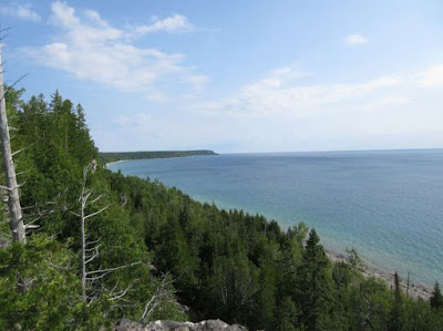
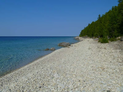
go back some day, but for now, here is a selection of our best pictures.
 |
| Members of the Peninsula Club, heading out to do some trail development. |


On my way to do a solo camp - hick to high dump and back. Nothing serious, but 1st solo camp. Reading your trip journal has got me excited. So, thanks! I have a bone to pick with you though - where are the Northern Lights pix?!?!
ReplyDelete